Web Soil Survey (WSS)
Web soil survey is an online repository that contains data and information produced by the National Cooperative Soil Survey. It is operated by the USDA and is the largest natural resource information system in the world. It is composed of data from 95% of United States counties and is the single dependable source of soil survey information. The soil surveys that are generated using this program can be used for general farming and local area planning (Web soil survey, n.d.).
Soil Survey in a section of Stony Creek in Dinwiddie, VA
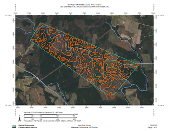
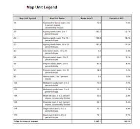
The soil survey that is generated using WSS describes the different types of soils in the area of interest (AOI). The soils are described in terms of their composition, their relationships to one another, and uses. Each individual area that is outlined within the AOI is a delineation. These areas are drawn when there is a significant change in the composition of soil. The map legend shows acres of particular soil types along with the percentage of area covered by soil type.
Hydrologic Soil Groups in a section of Stony Creek in Dinwiddie, VA
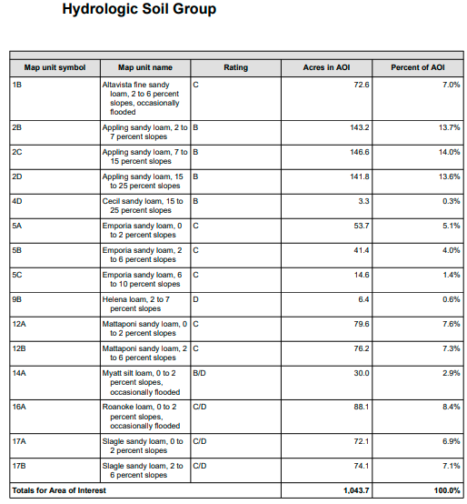
The hydrologic soil group survey was generated based on estimates of runoff potential. The areas outlined in the map are assigned to four different groups (A, B, C, & D) and three dual classes (A/D, B/D, and C/D). Soils assigned group A have low potential for runoff. Soils assigned group B have a moderate runoff potential. Soils assigned group C have layers that prevent infiltration of water and therefore runoff potential is significant. Soils assigned group D have a high runoff potential. Whereas soils assigned dual designations the first letter is for drained areas and the second letter corresponds to undrained areas.
Usability of WSS
As someone who has never used WSS I found it fairly easy to navigate and generate which survey and data sets I was interested in. There is a bit of a learning curve deciding which surveys you want to generate due to the terminology/specifics related to soil science. Using the soil data explorer tab allows you to generate surveys that pertain to suitability and limitations for use, I found this tab a bit overwhelming as there is much information that can be generated and I was unfamiliar with many of the terms. It would be helpful for novice users if they added a scroll over feature that gave a brief explanation to users of the information that would be generated. Additionally the AOI polygon tool in my opinion is quite difficult to use and should be replaced with an AOI drawing tool. This would make it much easier to identify AOI's that do not have a linear structure. In overview this is a tremendously useful tool that allows the user to generate a multitude of surveys that can aid stakeholders in decision making
. References:
Nrcs. (n.d.). Web soil survey - home. Retrieved July 6, 2022, from https://websoilsurvey.sc.egov.usda.gov/App/HomePage.htm

Comments
Post a Comment